
The Route - Part 1
Base Camp
In the late 1950s and early 60s, excavations were carried out at Carr Hill, Kirkham. They confirmed what had long been suspected from various finds over the years, that there had been a Roman fort there. It was only in 1980 that some of the results of the digs were published, in the late F. J. Singleton's short history of Kirkham. In 1994 an excavation conducted by Lancaster University revealed the ramparts of the fort.
The Romans' need for this fort can only be guessed at. However, as Frank Singleton pointed out, it would have had a commanding view of the Ribble. If Freckleton Marsh had then been covered by the river, its bank would have been much closer to the fort, making it another possible choice for Portus Setantiorum.
In Roman times, the fort at Kirkham would have been reached by the well attested road from Ribchester via Fulwood, Lea and Lund, referred to in medieval documents as “magnam stratam” and “Wattelingestrete”. There is, then, every reason to believe that a road existed as far west as the fort and no reason to dwell on it further.
Getting to the route of the problem
During the excavations in 1963, a narrow cobbled road was uncovered at a depth of two feet, leading from the presumed position of the west gate of the fort. It had been detected by the late Alan McLerie of Poulton, using a probe. It was photographed by the County Archaeologist, Ben Edwards, but its course was not followed for any great distance.
To proceed further west, we must turn to Thornber's paper to the Historic Society in 1851:—
“I had many a weary travel to find traces of the agger near the town. It is astonishing what pavements are discovered branching towards the north west, some of them sunk very deep in the ground.”
He ascertained that the “causeway” ran from the fort “nearly down the present street, crossing, rather nearer the church, a stream at that time, now a deep channel called the Skipbourne”. John Just, about the same time, remarked that “nearly the whole length of the long street of Kirkham is upon the Roman Road or in near proximity to it”.
According to Thornber, the road then continued “to the site on which stands the present Poorhouse, where you know it was discovered”. He was referring to the second workhouse in Kirkham, on the site of the present Health Centre, Moor Street. This is supported by R. Cunliffe Shaw, who stated in his book Kirkham in Amounderness, 1949, that his father had told him “many years ago that he had seen this portion of the Roman road exposed during the trenching in the old Workhouse grounds”. He had said that it had “a hard gravel surface about 25 feet wide and was kerbed with cobblestones; a horse-shoe was found in the gravel . . . similar to the Roman type”.
Cunliffe Shaw went on to mention that the farmer of Avenham Hall, Singleton, had claimed to have often cut through the hard surface of the road during draining operations and that it headed in the direction of the Wyre near Mains Hall, being well recognised by the farmers as the “Danes Pad”. Cunliffe Shaw admitted that this was well off the line traced by the Ordnance Survey and antiquarians.
The remains, if they existed, were presumably those of a different road. If only to avoid confusion, the term Danes' Pad should be taken to apply only to the feature described by Just and Thornber across Weeton Moss near Mythop, or to a projection of it. Thornber, himself, did not help matters by suggesting that a wooden “trackway” north of the Wyre, which he had earlier called Kate's Pad, should also be called Danes' Pad. It was then thought to be Roman, but radio-carbon dating has since shown it to be Bronze Age.
Returning again to Kirkham and Thornber, he next writes “Before I was aware of its being here, the name of Wrangway - bridge, which is thrown over the Dow in its vicinity, had led me to expect to find the agger near it”. It is not clear why this should have been expected, either from the bridge's name, which derives from the Old Norse for “crooked”, or from its location, which seems too far to the north.
He continues: “A little farther a section of it is to be seen in the stunted oak field, the property of a Mrs. Moon: the tree grows upon it. I cannot tell how we missed the spot when I pointed out the line of the road to Mr. Just and the officers of the Survey”. The present writer has failed to locate this field using the 1851 Census Returns for Kirkham and the Tithe Schedules of 1837.
Thornber next states: “From this field stretching up Ribby Brow, anciently written Rigeby, the town on the ridge, I discovered it from the circumstance of a farmer carting away a coarse red sand opposite Tarn-brick-farm-yard gate. On enquiry, I found that he had been in the habit of taking away its materials for years, as it formed a ridge on one side, the left, of the highway.” None of this seems significant as red sand is apparently quite common in the Kirkham area. However, the linking of the name “Ribby” with the word “ridge” is supported by the etymologist, Ekwall.
From this point to near Westby Mill, John Just thought that the Roman road coincided with the line of the main Preston to Blackpool highway. He stated that numerous Roman remains could be detected all along the side of the modern road. It is here that its supposed line commences on the first six inch O.S. map.
The highway to Blackpool has undergone many changes since then. In 1913 it had to be diverted at Westby to allow for the construction of the reservoir, and a roadside inn, the Clifton Arms, had to be demolished. Part of the old route can be seen beyond Whinbrick cottages, where it survives as a track to the reservoir. It re-emerges on the west near Westby Catholic Church.
Two windmills once stood on the site of the reservoir, one surviving into the 1870s. On the first six inch O.S. map, before the latter is reached the old highway turns a little to the south, whereas the supposed line of the Danes' Pad is made to carry on to the windmill where it veers to the north-west. John Just thought that he could see traces of the Roman road at Westby Mill Hill, but neither Mr. Hall of the Ordnance Survey nor Thornber would vouch for these “as the nature of the ground is gravelly and the signs of an agger doubtful”. Nevertheless, Thornber was convinced that the road ran there and added that an old man named Segar had claimed to have “ploughed through it many times and oft”.
The 19th century antiquaries had little to say about the section between Westby and Weeton. Margary's book Roman Roads in Britain, of 1955, mentions it “just east of Great Plumpton, where the agger, 1 to 2 feet high, is clearly seen crossing a meadow towards the railway”. No grid reference is given and, as far as can be determined, no writer has previously mentioned this feature, which seems strange. Philip Graystone in his book Walking Roman Roads in the Fylde and the Ribble Valley, published in 1996, associates the feature with a ridge visible in a field north of “Oakfield Farm”, heading north-west towards the site of the former excursion railway line from Kirkham to Blackpool Central. Graystone's vague description appears to relate to one of several hummocky fields to the north of Great Plumpton. The fields to the east of the village have reportedly been re-levelled in recent years.
Thornber (1851) does mention traces of the road in Weeton, and his words are recorded here to assist in locating the spot:-
“If we meet with the road before we arrive at Thomas Jolly's, Weeton . . . it is in a cop in the hollow before you rise the hill to his house, but I insist not on it . . .”
Thornber may not have been a complete romantic, but he could certainly be vague and obscure. Once again, it has not been possible to identify the spot to which he was referring.
In for a dig
Moving beyond Weeton, at last a stretch is reached that has been the subject of modern professional archaeology. In the early 1970s, before work was due to begin on the M55 motorway, a team from Manchester University's Department of Archaeology cut a section across the assumed line of the Danes' Pad where the line of the motorway was to cross it.
According to a report typed by the late Alan McLerie of the (Blackpool &) Fylde Historical Society, presumably based upon information obtained from Prof. G. B. D. Jones of the University, two trenches were cut across the road alignment at grid reference SD377342. They showed that the line of the road lay some 30 metres to the west of that suggested on the six inch O.S. maps. In both sections the actual road surface had been heavily damaged by modern ploughing, as the core of the road lay only 25cms below the topsoil. However, the existence of the road was shown by the presence of a clay platform some 5.2 metres wide by 25-30cms thick, resting on the natural dark-brown clay. The clay spread of the road platform was, by contrast, yellow-brown and terminated in two side ditches, which in the best preserved section (trench 2.) were nearly one metre across. In both side ditches, and particularly on the western (lower) side, the ditch sump was filled with silted gravel washed down from the original road surface. The same features were found in trench 1., where the clay platform for the road had suffered considerable damage from ploughing. The method of construction was taken to show the way in which Roman road engineers adopted local clays as a substitute for stone foundations in an area with no surface stone readily available. If the grid reference quoted by McLerie is correct, the trenches were in fact positioned about 100 metres west of the assumed line and some 200 metres north of the line of the M55. More worrying, though, the site is uncomfortably close to that of a short farm track shown on the first six inch O.S. map of the area. Is it possible that the archaeologists were attracted to visible remains of this track?
Crossing Weeton Moss
Any road into the western Fylde must at some stage cross a long peat-laden valley. Following what is prosaically called the Main Dyke upstream, it winds south from the Wyre at Skippool before opening out in the Ballam and Marton Moss area. It is thought to have been a melt-water drainage channel at the end of the last ice age and the peat along its length formed within the last 7,000 years.
Across the part of the valley known as Weeton Moss, an embankment of gravel was visible at least until the end of the 19th century. It was generally taken to have been a Roman road. Thornber was by no means the first person to write about this feature, for as early as 1823, Dr. T. D. Whitaker in his History of Richmondshire stated:—
“About three miles south of the town of Poulton, the agger of a Roman Road was distinctly visible till within the last ten or twelve years, since which time immense quantities of gravel have been conveyed away for repairs of the roads and garden walks.”
This ties in well with Thornber's assertion in 1851 that he remembered, when a boy, how it was impressed upon Whitaker by Mr. Wilson of Poulton that tradition had handed it down that an agger ran from Ribchester to the Wyre. About “ten years or twelve years” before 1823, Thornber would still have been a pupil at the school of which Mr. Wilson was the master. It would seem that Whitaker had based his account upon information supplied to him by Mr. Wilson.
In 1851, Thornber described the Weeton Moss section as follows:—
“. . . we here crossing the highway to Mythorp and a valley, have a sight of the highest ridge on the whole line, indeed so large and bulky as well worthy of the skill of a railway contractor; there it is, though diminishing yearly to supply gravel for the township highways to the neglect of the open pits out of which it was constructed. It is called the Danes'-pad, and its hardness has given rise to the proverb, as hard as the Danes'-pad. These pirates, no doubt from Wyre, made their inroads along its path, and their cruelty and sojourn is so well remembered by tradition in the Fylde, that every remain of antiquity is pronounced Danish.”
Being so clearly visible, this stretch of the Danes' Pad is the first to be “double-lined” on the first six inch O.S. map. John Just noted that the gravel here seemed to have been brought from the debris of some river. However, it should be mentioned that there are several natural outcrops of gravel in the higher ground surrounding Weeton Moss, as evidenced by field names like Gravel Hill.
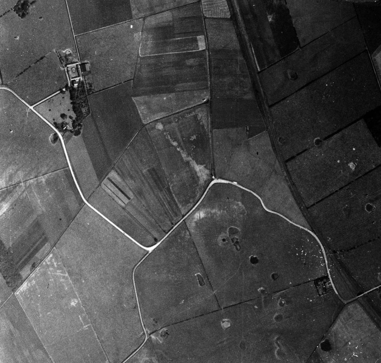
Something of the feature across Weeton Moss did survive to be photographed in 1945. On this vertical aerial view a lighter “stained” area in a field corresponds well to the “double-lined” section on the map (compare with page 21). The “stain” probably results from a preponderance of gravel in the otherwise dark peaty soil.
Writing about the feature in 1837, Thornber did not remark on its size, merely stating that from “Green-lane-end” it ran across the Water Course and the “Cowland” before passing over “Fluthorns” and “Six-acres”. Oddly, the fields to which these names are thought to relate all bear other names in the Weeton-with-Preese Tithe Award of 1840 (Carr, Hawthorne and Marled Field). He then went on to say that “its line in these fields and meadows was easily traced not many years ago”, which seems at odds with his remarks in 1851, above. Watkin wrote that he “can vouch for the existence of this fragment until March, 1881, but comparatively little reduced in size”. Indeed, in February 1895 the Blackpool Gazette & News reported:—
“Thomas Miller of Singleton has given instruction that the portion of the (Roman) road through the Fylde which runs through Weeton Moss, and is one of the best specimens in the county, is to be strictly preserved and no more gravel is to be taken from it.” Mr. Miller's instructions were obviously ignored for, today, little or nothing is to be seen.
Getting in another dig
In 1984, the (Blackpool &) Fylde Historical Society had obtained permission from the farmer of Mythop Hall to examine his land. To the south-east of the farm, just north of a dyke (grid reference SD372349), a small ridge was noticed in an otherwise flat field. Along the ridge, which followed the still double line of the Danes' Pad on the map, the soil was very stony, contrasting with the soft peaty soil elsewhere in the field.
On 16th August 1984, a team comprising members of the Preston & District Archaeological Society, led by Jack Ainsworth, and members of the (Blackpool &) Fylde Historical Society, led by the late Frank Gardner, a keen amateur archaeologist, dug trial holes into the ridge to determine its composition. Despite the crude way in which the dig was carried out, it did produce some interesting results. Mr. Ainsworth described what he had seen as follows (The sketches are based upon his section drawings.):
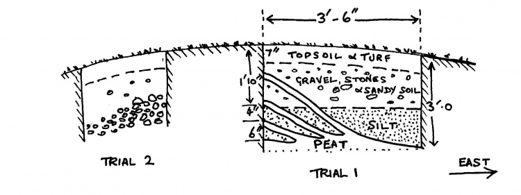

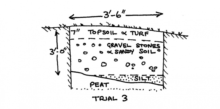
“The excavations revealed that the ridge (50ft. long, 20 ft. wide and 3 to 4 ft. high) consisted of about 7 inches of topsoil and turf on a heavy concentration of gravel, stones and silt on a bed of peat at about 3 feet below the surface, with rising bands of peaty deposits containing leaves, twigs, seeds and the remains of grasses and rushes indicating that the ridge had been the edge of an ancient lagoon which had advanced three times. There was no evidence of man made construction in the gravel deposits.”
What were they looking at?
This interpretation of the findings does not preclude the possibility that a road across Weeton Moss created an artificial bank for a lake formed there at some subsequent period. Alternatively, a road may have avoided an existing mere by skirting its shore or may have used the remaining hard pebbled shore of a former lake or river as its foundation at this point. Interestingly, on Yates's map of 1786 the northern edge of Weeton Moss is shown in this vicinity, suggesting that the feature then formed a boundary. The O.S. map of 1845 shows that the Moss had by then receded much further south, although the highway from Weeton to Mythop was still shown by dotted lines across the low ground, where today it is on an embankment.
In 1731 and 1741 the size of Marton Mere, to the west, was drastically reduced by the cutting or enlargement of the Main Dyke north of Mythop and, to judge from the depth of the cutting in parts, it must have been a major undertaking. It was effected by Edward Jolly of Mythop and later by William Jolly, as detailed by R. Sharpe France in the first transactions of the Fylde Historical Society in 1940. As the Main Dyke goes on to flow through the valley of Weeton Moss, it is likely that the drainage of the Moss north of the Danes' Pad also dates from this time.
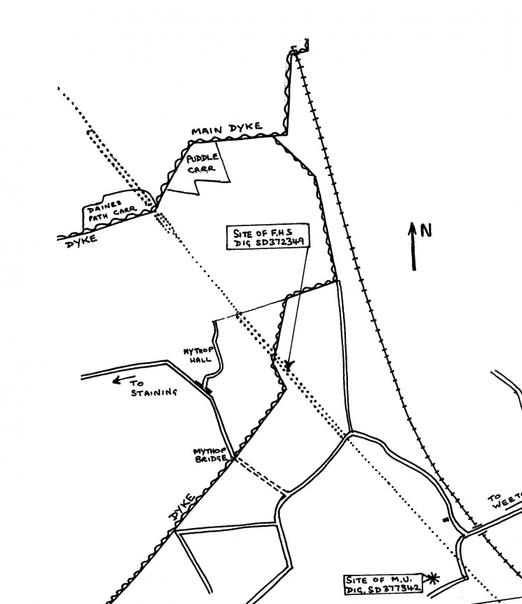
Is it possible that the Danes' Pad was constructed by the Jolly's to facilitate access to the dyke while the work was proceeding? Alternatively, it could have been built about this time to link Weeton and Staining, thus avoiding Chain Lane, shown as a private road on the 1845 map, with “Mythorp Toll Gate” just north of Thatchplatt Bridge over the Main Dyke. Later ownership of the land may have precluded its use as a road.
The line of the Danes' Pad shown against the lanes, tracks and watercourses of Weeton Moss in the mid-19th century.
Interestingly, early in 1996 two Roman coins were found by metal detector in the field immediately to the north-west of the above mentioned bridge. This is well to the west of the line of the Danes' Pad and the field would have once formed the bed of Marton Mere. The coins had probably been thrown in.
Accepting that the Danes' Pad once formed a sizeable embankment over Weeton Moss, it is strange that field boundaries take no account of it. This could be taken as meaning that the road was constructed after the fields had been marked out following the draining of the moss. However, there is still the possibility that, after the field boundaries had been drawn up, drainage caused the land to shrink, revealing a much older feature. Peat-cutting might have produced a similar result.