
Map 5 Preesall with Hackinsall - North
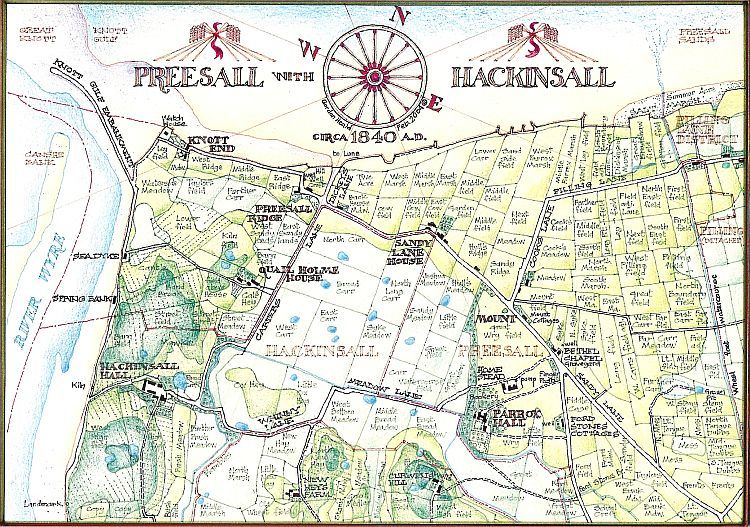
During the 1830s the government realised that the old system of payment of Tithes in kind was no longer viable. A survey of every parish and field in the country was therefore undertaken, scheduling field names, current usage, premises, tenants, owners and values, related to numbered maps. Three copies were made; for the govt., the bishop and the parish. Preesall with Hackinsall is fortunate in having a high quality survey, of which all three copies survive. When combined with the first Ordnance Survey maps of the 1840s, produced in Lancashire at a scale of 6 inches to 1 mile, they result in a uniquely detailed record.
Many of the field names in Preesall with Hackinsall can be traced back to the 12th. century, ie. Cook's Field, Cook's Meadow and Cook's Lane relate to Adam Cook's Land mentioned in a grant to Cockersand Abbey. Boundary lines such as that of Pilling Lane District are described in detail in a similar grant, ie. "from the Stockenpool, where the cross is set up, in a straight line southwards to the cross upon the Tongue and from there by a certain ditch, between carr and Tongue, on the east, to another cross on the Black Lake bank," etc., etc.
Other names describe the type of land such as Rush, Carr, Marsh, Moss, Syke, all these relating to low lying wet ground; or Stanifurlong, the stony furlong, which can also be traced to the 12th. century. Still others indicate former features which may have existed, ie. three fields in a line with the word 'street' in their names would seem to indicate the existence of an ancient road.
Traces of ancient ridge and furrow ploughing remain, particularly on what is now the golf course, and the name of the present spreading settlement of End was then only A applied to the very extremity adjacent to the , the centre of the modern village being called Preesall Ridge. At that time every tide, even the neaps, reached what by then were well developed sea walls. Now, due to the process of accretion described in the 1907 Royal Commission on Coast Erosion, mean high water is accepted as being 750 metres from the shore.