
The Route - part 2
Down in the Valley
Following the Danes' Pad further on the six inch O.S. map of 1845, it passes to the east of Mythop Hall, where its line becomes single once more as it reaches the high ground. Members of the (Blackpool &) Fylde Historical Society dug trial holes in this area in 1984, but found nothing. As the line continues into the next valley, it again becomes double before terminating abruptly just south of the Main Dyke. However, it re-emerges north of the dyke, double-lined and still on the same north-westerly alignment as the Weeton Moss section.Here it clips the eastern corner of a field called “Daines Path Carr” in the Hardhorn-with-Newton Tithe Award of 1838.
It would be nice to be able to regard this as solid folk-lore evidence for the Roman road. But it does seem strange that Thornber, who seems to have been fond of quoting field names, should not have mentioned this one, out of all of them! By 1838, the farmer is likely to have known about Thornber's explanation of the feature in the field, either directly or through his History of Blackpool. Unfortunately, publication contaminates tradition and there now seems no means of proving that the field was not given its name at this time.
Thornber had written in 1837 that, going south, the road “crosses the ‘Main Dyke’, in the cutting of which its materials were particularly observable; thence it stretches across ‘Puddle-carr’, where it lies on the moss to the depth of two yards in gravel”. Although the Tithe map shows Puddle Carr to be south of the dyke, it lies about 250 metres to the north-east of where the Danes' Pad crosses the dyke on the O.S. map. Once again Thornber's description can be seen to be misleading or confused. It may be significant that he had a drink-problem, through which he was forced to resign his living a few years later. Fortunately, his account of 1851 is more coherent:—
“After passing over the next hill from Weeton, we behold the agger crossing another valley, through which a ‘main dyke’ has been cut, bisecting the road. We are now near Benson's Farm, Staining, in the Parish of Poulton, and not far from its Mere, generally known by the name of Marton Mere, where on the cutting of the above mentioned dyke, the waters left bare a brass celt, two skin boats, and a skin cap without a seam. These the Rev. Mr. Buck inspected in Poulton. Many shoes and pieces of iron have been taken yearly out of the causeway here, as its materials, land gravel, are carted away for the repair of the highways. I have measured it and found its breadth at the crown about twelve yards and its base twenty, whereas on the sound land it is not more than eight or ten yards. There are no signs of ruts — and I doubt whether any wheeled carriage was used thereon — whilst I can prove that sledges were; for as we walk up to the farm-house and look at the oak-posts at the first gate, we may see the sides of a sledge which were dug out of the agger.”
Watkin wrote that the gravel here was two yards in thickness as late as 1880. Yet, on the first 25 inch map, produced 12 years later, the road here was represented by just a single dotted line.
John Just, tracing the route south from Poulton in 1851, wrote:—
“But having got over the higher ground and come to a part of the flats of the Fylde district, we meet with striking remains of the road on the turfy grounds where it has been piled up in an immense bank or agger; and serves as it has done for years past, as a gravel bank for getting materials to mend and keep in repair the common roads of the country. Across this mossy flat the line is very distinct, and as therein ditches separate the fields in lieu of fences, frequent sections of the road are made particularly by the water-cuts made for the drainage of the district, some years ago. On the higher grounds the whole line has long been obliterated, and we are not favoured with any other evidences of the course it has taken, until we again detect it in a low hollow, towards Weeton Moss, which has not come within the general influence of the drainage just mentioned. Here is an immense embankment of several yards in height, its base standing in the water which cannot get off, from the isolation of its situation”.
From its position within Just's text, the “immense embankment” appears be describing the Main Dyke section, but it is strange that it should have been “standing in water which cannot get off” because the dyke ought to have provided adequate drainage. It is conceivable that he was referring to some hollow in the higher ground north-west of the dyke in the vicinity of Hall's House Farm. The Main Dyke section on the first six inch map is “double-lined” as far north as a little east of the farm (grid reference SD364358). Not only do later O.S. maps show just the Danes Pads' assumed line in this area, but, quite irrationally, they show it to veer from the double line of the first map, as if “pulled” by the Puddle House Farm section a mile further north.
It is one thing to imagine a Roman road from a scattering of stones, but, here, independent observers were clearly describing a substantial feature. If anything, it is too large. So perhaps alternative explanations for such an embankment should be sought. Could it possibly have been a temporary dam constructed in the 18th century to facilitate enlargement of the Main Dyke downstream of it? Similarly, perhaps it could have been a medieval dam associated with a water mill at Staining mentioned in monastic charters, or even that at Great Marton. If this were so, it might at the same time explain why, up to the 18th. century, Marton Mere drained to the west, whereas a glance at a geological map suggests that it should naturally drain to the east. Of course, a substantial Roman road at this point could have had the same effect. There is otherwise the difficulty of explaining why a dam should be perfectly aligned with the Weeton Moss section of the Danes' Pad, unless the officers of the first survey had not been completely objective and the alignment was imagined.
In August 1958, members of the (Blackpool &) Fylde Historical Society, led by Mrs. Gorrie, dug in “Daines Path Carr”. Unfortunately they had chosen a spot 70 yards to the west of the line on the maps, having been attracted to a ridge across the field. This was found to have been a filled-in trench for an old drain! In 1983, members of the same society dug several trial holes in the east corner of the field, but nothing other than peat was found.
In the mire
The third and last “double-lined” section on the six inch O.S. map only appears a mile further on, but this time on a more northerly heading. Thornber described it in 1851 as follows:—
“. . . we meet with the road again beneath the village of Hardhorn, near Paddle House. It is plain enough, though the gravel has been removed, and it is making direct to Poulton, which is not far off. Here ends every trace which I dare to vouch for;”
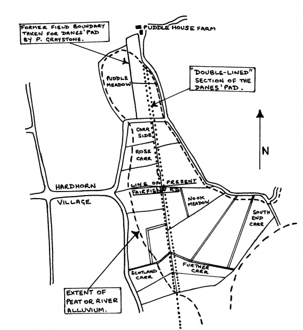
The sketch to the right shows the Puddle House Farm area in the mid-19th century showing lanes, with some fields and the “double-lined” section of the Danes' Pad.
The double-lining continues until the road merges with the farm lane, a few yards short of Puddle House itself. It is not clear why Thornber should refer to it as “Paddle House”. Philip Graystone (Walking Roman Roads, 1996) maintains that earlier documents give it this name and he suggests that it might derive from the name “Danes' Pad”. However, entries in the Poulton Parish Registers as early as the mid-17th century still show it as “Puddle” or “Pudle”, a name generally associated with marshland. In his book, Graystone identifies a ridge passing to the west of the farm as the Roman road, and even shows a photograph of it. Unfortunately this is just a former field boundary, which can be seen on the first six inch O.S. map running parallel to, but west of, the double-lined section of the Danes' Pad.
Elsewhere on its route from Kirkham the Danes' Pad has kept to the high ground or has taken the shortest way across any valleys. Its route has always been a plausible one. It seems inconceivable that the practical Romans would have crossed what was then probably a peat bog to Puddle House Farm, when a little to the west was the hill at Hardhorn and to the east more high ground.
Significantly, this is the only section where the road follows field boundaries, most of which are adjacent to a ditch. It is more likely that Thornber and the Ordnance Survey mistook material taken from the ditch and an old farm track for the Roman road.
It should be borne in mind that, if the evidence for this stretch of the Danes' Pad is rejected, there is less reason to look for or expect signs of the road further along the same alignment. What remains is some evidence for a Roman Road heading towards Bispham!
An alternative theory
Porter's placing of Portus Setantiorum at the mouth of the Wyre has so coloured thinking on the Danes' Pad that it may serve a useful purpose to provide a different postulate, if only to free-up a few minds.
What if the Danes' Pad had, in fact, continued in the direction of Bispham? In Roman times it would have reached a coast at least a mile further to the west than the present one. More significantly, most of the land near the coast would have then been well over 100 feet above sea level, for contour maps suggest that the Bispham's cliffs and Warbreck Hill are all that remains of a moraine once as large as that of Kirkham. Such a location would have been ideal for a coastal lookout fort protecting Morecambe Bay and the Fylde from seaborne attack. Such forts are known to have existed along the Cumbrian coast to prevent Hadrian's Wall from being outflanked. What better place would there have been for one on the Lancashire coast?
Such a postulate seems just as plausible as Porter's theory and, like all enduring legends and religions, it is placed all too conveniently just beyond proof or disproof. However, as nothing has ever been found in the direction of Bispham, a more northerly path must be followed.
Poulton and beyond
Thornber's paper of 1851 goes on to state:—
“yet it is said that the causeway gained the top of Poulton-hill, by the Church Sunday School. I affirm it not: neither do I say there are some marks of a square fosse around the Church-yard. Certainly there was a peculiar ditch and a high bank that surrounded it, with the exception of a portion on the south near and at the great church gates. This I do know, that I saw two copper coins of Adrian in the possession of Mr. H. Wilson which had been found near the church, and I am assured that Mr. Crossfield, of Kirkham, has a pretty large medal of Germanicus, which was taken by Miss Threlfalls from a garden behind the market-place. Mr. Just fancied that Poulton might have been the Portus, and the pool of the Wyre and the Skippon, half a mile distant, the rode or statio navium. I rather fancy that the agger ran past Poulton on to the Town-fields near Little Poulton Hall, having only a branch to Poulton Hill. On the high ground of the Town-fields there is a track of an ancient road which evidently was gravelled over the low lands, and this road leads by a curious cut through the banks of the Wyre to the Shard, or as anciently written, Aldwath, or the old Ford, so denominated before 1300.
“The agger could not go to the mouth of the Wyre over Thornton Marsh for obvious reasons. But the Bergerode of Wyre, so called in old maps, was between the hill of Bourne Hall and that of Stana, and in my opinion was approached from Skippool. It is singular I have paid little or no attention to Stana, although it has been in my mother's family for a century, and I fancy something has been said of ruins there — and an agger could approach it from Poulton. At Bourne, which is marked in the Doomsday survey by mistake of Baines, as Bryning near Lytham — there are certain rough grounds named Danes' Pad by the country people. Rawcliffe, anciently in Doomsday written Rodecliffe, and the commencement of Kates' Pad, lie across the water nearly opposite, and Wardless, where till Fleetwood was founded, was the rode of shipping for time immemorial; and these places might have been gained from an agger to Stana by the old ford of Bulk across the Wyre. Of Fleetwood I must say little; but that in 1840, between Rossal Point and Fenny, some brickmakers discovered a treasure of some 400 silver denarii, consisting of the coins of Trajan, Adrian, Vespasian, Titus, Domitian, Antoninus, Severus, Caracalla, Sabina, Faustina, &c. I possess 40 of them, and myself and brother here saw destroyed, for the sake of its materials, a large paved platform, which I had often fancied had been used as a landing-place. At this spot I have heard old people speak of the ruins of a rude, thick-walled, circular building, round which it was uncanny to sport.”
The founding of Ben and Margaret Edwards' Lancashire Archaeological Bulletin in 1975 precipitated a flurry of articles on the Danes' Pad, just as that of the Historic Society of Lancashire & Cheshire had 125 years earlier. Julia Beeden of the Pilling Historical Society wrote in the third issue that in 1968 she had realised that any Roman road going north from Poulton would probably be intersected by Amounderness Way, then under construction. The foreman on the site confirmed that a cobbled road had been broken through, which she was then able to trace from Poulton to School Road, Thornton.
The following issue of the bulletin contained an article by Alan McLerie, confirming the existence of the cobbled track and tracing its course south from Ardelles House (grid reference SD349411) across golf links, where its line was revealed by discoloured grass, towards the grounds of Poulton College, now Wyre Civic Centre. He noted that:—
“Almost immediately after crossing the Breck Road at the College, and entering the line of Station Road, it comes onto the northern end of a remarkable boundary hedge, appearing on the older O/S maps, but now almost entirely obliterated by modern development, which runs almost due south, without break for 2.25 kilometres. At one stage it forms the western boundary of the field called ‘Purgatory’, and extends as far as ‘Puddle House Wood’.”
McLerie also noted that on the 1845 six inch O.S. Map the track turns 45 º to the north-east where Ardelles House later stood and that, continuing in this direction, it appeared to making “for that conspicuously elevated point on the western bank of the River Wyre opposite Wardleys”.
He needed some prodding
In the fifth issue of the bulletin, there appeared an article by J. C. Plummer supporting Porter's placing of the Portus Setantiorum off the coast at Fleetwood. He too had traced the road across the golf course and, using a probe, had located it in the grounds of the College, south of the railway line. However, he ventured that the latter was part of a Roman road branching off the first road in a north-westerly direction towards Thornton and perhaps Fleetwood. Mr. Plummer, incidentally, claims to have located several other Roman roads in the Kirkham and Freckleton areas, using a probe and by dowsing. Both methods may be regarded as being highly subjective.
Mr. McLerie's hedge, however, has more recently been pointed out by the historian, Dr. Alan Crosby, as a significant old boundary which separated the Poulton town fields from its moor land. But a simple mundane explanation for the track across the golf-links is apparent from a study of the first one inch O.S. map (David & Charles reprint, sheet 15). On it, what is now called Little Thornton can be seen to have been the original nucleated settlement of Thornton, from which lanes spread out in all directions. The imagined Roman road can now be seen to be just one of them. This lane, which is not particularly straight even at this small scale, would have linked Thornton with the Breck and Poulton, before being cut in two by the Preston & Wyre Railway of 1840.
Town End Farm, Thornton
A brief newspaper report of 1935 mentions that Richard Ainsworth, a Cleveleys historian, took members of the newly formed Fylde Historical and Antiquarian Society to Town End Farm, Thornton (grid reference SD332434), where he was able to show them traces of a Roman road. The society's secretary, R. Sharpe France, does not appear to have been impressed, as there is no mention of the visit in his minutes. However, a letter, dated 15th. July 1935, to Sharpe France from another of the society's founder members, Eric Porter, survives and the following are extracts:—
“. . . It seems that Mr. Cowell, the present farmer, was told by Mr. Walsh, the previous tenant, of finding large stones etc. which were believed to be part of the Danes Pad. This was around a place which was indicated to me by Mr. Ainsworth.
“. . . In or off West Drive in Thornton, Mr. Ainsworth indicated the remains traditionally known as the Danes Pad. This is on land which is farmed by Mr. Bradshaw. The land is being rapidly built over but this depression, roughly 10 ft. wide and 1 ft. deep, is very clearly defined.
“. . . Mr. Bradshaw is willing for us to do whatever excavation we might wish to, and I suggest to you that we might take full advantage of this offer. We might have a word with the builder whose new houses run across it, or with the new householder whose potatoes seem to be doing particularly well on the Pad.”
In October 1935, Porter interviewed Mr. Walsh, then in his late nineties. In the orchard at Bourne Hall (grid reference SD333443), Walsh claimed to have uncovered what was taken to be a Roman road. It comprised large cobbles or setts “such as were usually used in the construction of roads at the time”. Only a small area was uncovered and the direction of the road appeared to be northwards. In fact Thornber had written in 1837 that the course of the Danes' Pad could be traced “along the Naze, by Burn Hall, in the direction of Poulton”.