
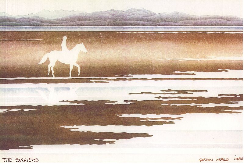
The Sands
Morecambe Bay is a designated European Marine Site, a Special Area of Conservation (for its habitats), a Special Protection Area (for its migratory birds), and a Wetland of International Importance. It also contains a Special Site of Scientific Importance, the Wyre Estuary.
Preesall Sands, at low tide more than 7 sq. miles of beautiful, clean, firm sand, beloved of anyone who has ever explored their boundless expanse, occupy the south side of this amazing bay, with panoramic views of the Cumbrian mountains the Bowland hills and the open sea, even sometimes as far as the Isle of Man. (To see the current state of the tide click here).
In September 1837 William Thornber, Vicar of Blackpool, wrote what can only be described as a Hymn of Praise to the local sands, even more applicable to those of Preesall than to Blackpool, as follows:-
"These sands need no panegyric of mine; without exception, they have no equal,or rival, in the Kingdom, for extent, solidity, and pureness. I never took a ramble on them without vowing to frequently renew it, so elevated were my spirits, so refreshed and invigorated was my whole system, every part of my body glowing with the exercise, and my face mantled with the healthful breeze. Often have I been induced to exclaim, if the far-famed elixir vitae is to be discovered, if a specific against debility, pain, and disease is to be met with, it must be sought for in the vicinity of the sea, on the brink of the ever flowing wave,"
These sands, beautiful as they are, have been the graveyard of literally hundreds of ships, wrecked down the centuries: the gaunt remains of a few of them can still be seen, their bony ribs sticking out of the sand like the skeletons of strange prehistoric creatures.
Gordon Heald and Tony Heyes roamed the extremities of the sands many years ago as boys, and began a project to map the positions of the few remaining visible wrecks by taking compass bearings from known features. the task was never finished until in the year 2000 the two old friends got together again and decided to complete the job, and have some enjoyable walks as well, using Tony's GPS to plot the positions of the wrecks.
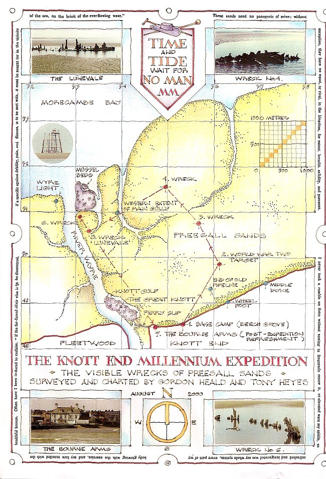
The map illustrates the result: a five mile circuit encompasses all the wrecks shown, a good walk for any reasonably fit person. But be careful, be well aware of the state of the tide and the weather, carry a compass and a mobile phone,stay away from soft or muddy areas, and respect the prolific wildlife. Who knows, you may discover even more secrets!
If contemplating a walk on the sands please visit
Notes on the wrecks
The World War 2 Target
The Target was a large wooden platfom held in postion on the sands by three large anchors. The platform had a yellow pyramidal superstucture topped by a round black ball about five or six feet in diameter. Close by were the remains of an earlier target, clearly one that had received a direct hit. The targets were used by the Fleet Air Arm for dive bomber practice.
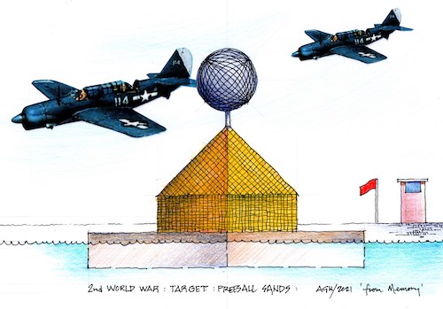
Gordon's drawing - from memory- of the Target also shows the Red Flag, hoisted on the shore, to warn people of imminent action.
American built Curtiss SBW-18 Helldivers were used by the Fleet Air Arm but no doubt badged in FAA insignia.
David Trippier recalls:-
On the 6th October 1944, one such 'Hell Diver' buried itself well and truly in the sand when it crashed trying to pull out of its dive. In the 60s all that remained was a big pool and odd bits of twisted aluminium. ( See the Accident Report) One couldn't really tell it was a plane,it was only through local knowledge that we were told what it was. My father and his brother remember the crash happening during the war years; it would be now called a war grave but not back then. After the remains of the pilot and his gunner/navigator were removed the wreck was left where it crashed so local kids and trophy hunters were all over it after the tide went out. We were told that my uncle Ron never forgot that crash as he saw it happen while watching the dive bombers practise on the target; he was sitting on the wall at the end of Clarence Ave watching the hell divers come in their steep dives.
They used to practice at night too, dropping parachute flares. The parachute silk was a much prized material during the war years, so locals from Knott End used to go out on the beach under cover of darkness and hide behind the anti-landing posts which protected the beach from aircraft landing; (the sawn off stumps of these anti-landing posts remained visible for many years after the war until eventually engulfed by the rising level of the sand). As the flares came down on parachutes the locals waited till they hit the sand and burned out, at which time the people emerged from behind the posts to grab a parachute or two. The beach was pitch black and the local police were supposed to be watching from the sea wall to deter this activity, so each time the next parachute came down they would hide again behind the posts as the beach was illuminated by the magnesium flares. Many bonds that lasted for many years were formed during this activity on the beach. Both going for the same chute, my father bonded with Jimmy Moss and they remained friends until their deaths. They often spoke about war-time Knott End and grabbing parachutes on the beach.
Wreck 3
Small unremarkable remains of a small fishing smack. Almost certainly no longer visible.
Wreck 4
The 'Pittan'; a three master carrying a cargo of pitch which was wrecked in the early 20th century.
Wreck 5
The old steam ferry boats were decommissioned after a steam pipe burst on the 'Wyresdale' and the plan was to scuttle her sister ship, the 'Lunevale', way out in Lune Deep. However, when being towed past the Wyre Light the towrope parted and Lunevale drifted, then grounded and sank on the Knott End side of the channel, becoming what we call wreck 5.
Wreck 6
A fishing smack.
==========================
World War 2 Coastal Defences
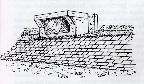
Read about "The World War 2 Coastal Defences" by clicking
.
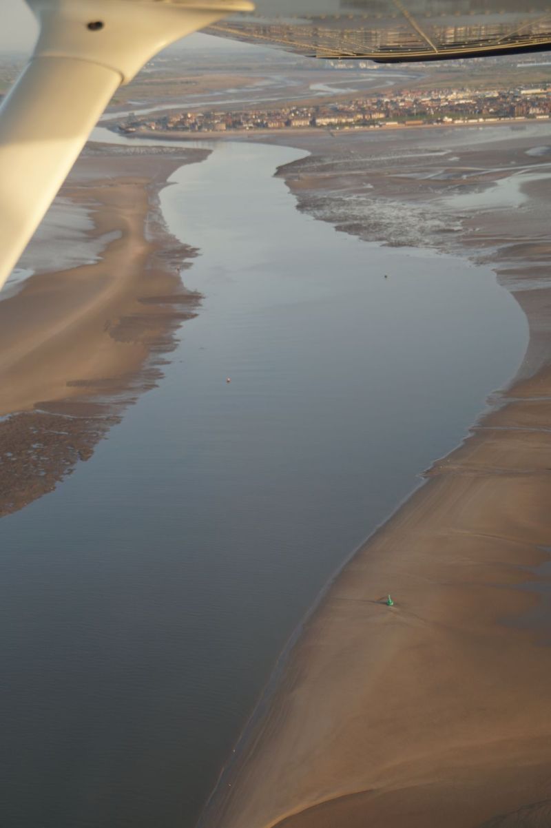
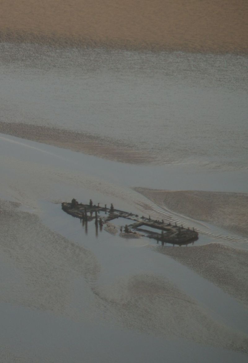
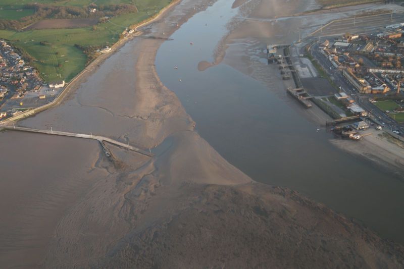
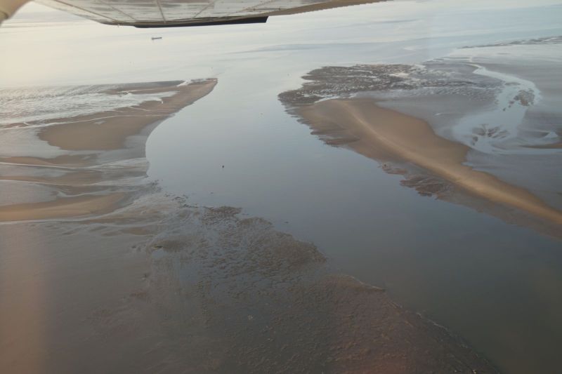
Aerial photographs of the sands
Gordon took these aerial photographs of the sands in April 2014 by courtesy of Frank Smith who very kindly took him up for a flight in his aircraft.
1. the Wyre Estuary looking south ( wreck No.6 now buried in sand )
2. Wreck No.5, the 'Lunevale' ( still very visible )
3 The Wyre at the Knott End- Fleetwood ferry. ( considerable build up of silt )
4. The Wyre estuary looking north. ( the channel is wandering now dredging has stopped )
5. Wyre Light ( massive corrosion to the main supports )
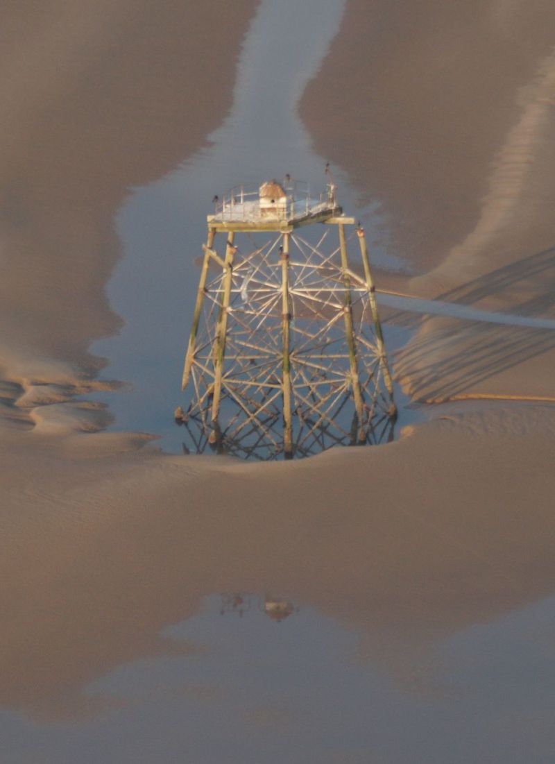
Gordon Heald writes:
Wyre Light is looking very sad these days since some of the supports have completely rusted through and the whole structure is leaning and sinking at an ever increasing angle so it is no longer visible at high tide. I remember the night in 1948 when the original wooden housing on the top was destroyed by fire - I was sound asleep in the front bedroom of my grandparents' house at No.16 Wyre View while everyone was outside enjoying the spectacle, and no one even thought of waking me up to see it. I would have had a grandstand view. Quite hard to forgive, even now !
Gordon also writes:
However, I have a very strong memory of standing on the front at the end of Wyre View at night watching Barrow in Furness being bombed by the Luftwaffe.