
Introduction to Route Numbers
The following pages show the sheets of maps reorganised from the numbering system used by the Lancashire Record Office, into an order which it is thought to be a more likely sequence used by the surveyors, when starting from Warrington and proceeding northwards
The maps have been presented into numbered Routes for easy reference. Each Route was started when the surveyor set his measuring wheel, called a dimensurator, to a zero reading. Some of the distances travelled appear to be very long for one day’s work but if the scribe was riding on a horse and regularly changing places with the pedestrian pushing the dimensurator and the third man, then the task seems feasible. Even allowing for food and drink stops, for both horses and men, the days would be long and tiring.
It has been assumed that from the starting point at the bridge over the river Mersey at Warrington they travelled north on the line of the Roman road to Lancaster via Wigan, Preston and Garstang. This section of the road is referred to as Watling Street in the Cartulary of Burscough Priory [c. 1230-1238]. After crossing the sands of Morecambe Bay a series of radial walks were measured around Cartmel. These were followed by a coastal survey moving clockwise from Grange to Haverthwaite then north along the east side of Lake Windermere to the county boundary. From there they followed the boundary over undulating rocky terrain to Winster measuring the distances using chains and range poles. The river Winster formed the boundary between Lancashire and Westmorland all the way back to Grange.
Returning over the sands they travelled back to Preston from Lancaster via the coastal route through Cockerham, Pilling to Poulton, using the ferry over the river Wyre at Chard. The winter route from Cockerham to Pilling went by Pilling Sands, because the summer route over the moss would be too wet. A second circuit to Lancaster was made on the country roads via Grimsargh, Goosnargh, Inglewhite, Garstang, Forton and Galgate. Whilst in Lancaster they went to the top of Clougha by the beacon and measured the way back.
Detailed surveys were made of the streets and the names of the inhabitants of both Preston and Lancaster. A measured survey was made of Wrightington Hall, the home farm and surrounding roads. The measured location of many houses with the names of the occupiers is shown on all the routes. There were 395 occupants residing in Preston and 93 outside Preston. The number in Lancaster is not included. It was in 1685 when Gregory King made this survey. He had visited the main towns of the area as clerk to William Dugdale during the 1665 visitation from the College of Arms. Dugdale, in 1638, was created a Pursuivant of Arms Extraordinary by the name of Blanch Lyon and in 1640 Rouge Croix in ordinary. In 1644 the king created him Chester Herald. At the Restoration he obtained the office Norroy King of Arms and in 1677 was created Garter Principal King of Arms and was knighted. Many years later Gregory King became Lancaster Herald.
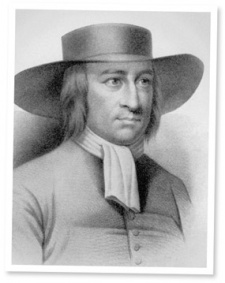
George Fox
The eminent Quaker George Fox had made the centre of the movement in the northwest at Swarthmore Hall near Ullverston. It was the home of Judge Fell, Cromwell’s chancellor of the duchy of Lancaster, who was friendly with the Quakers, whilst his wife Margaret, joined them. Fox had already been in jail four times when in 1663 he was brought before Magistrates at Holker Hall (see Route No 9). The Magistrates were, chairman of the bench Rob. Rawlinson of Cark Hall, (see Route 9) Joseph Fletcher of Birkby Hall, (see Route No 7) William Knipe of Burblethwaite Hall, (see Route No 15) Westby Esq. of Canon Winder Hall, (see Route No 10) Sir George Middleton of Leighton Hall and Colonel West of Bowick Hall. This large bench of heavyweights was an unfair match for Quaker George Fox, although he put up a good defensive case. He was sent to jail at Lancaster castle and later transferred to Scarborough castle and was released in 1666. He came back to Swarthmore Hall and in 1669 married Margaret, widow of Judge Fell.
Gregory King sketched Lancaster castle in March/April 1665 and the barn shown on the left of the castle may well be the place where George Fox preached.
Robert Rawlinson
Robert Rawlinson born in 1610 of Greenhead, Mereside and Cark Hall, Barrister at Law of Grays Inn and was Justice of the Peace for counties of Cheshire and Lancashire. After the Restoration, he was appointed Vice Chancellor of the City and County of Chester by which his fortunes were restored. King Charles II granted him arms on 20th May 1662. He married Jane eldest daughter of Thomas Wilson of Haversham Hall, Westmorland and had eight children. He died 30th October 1665 and was buried at Cartmell Priory Church.
At the Herald’s Visitation in 1665 of the Lonsdale Hundred, Rawlinson sent in a manuscript pedigree of his family. Back at the College of Arms Gregory King entered this and other pedigrees in the ledger.
In 1582 William Rawlinson of Mereside in Cartmell had two daughters. The second daughter’s marriage was to George Hutton of Thorphinsty Hall. ( Route No 15)
Route No 1 Warrington to Wigan
Route No 3 Preston via Howarth Moor to Ellel (Bay Horse)
Route No 4 Ellel Moor (Bay Horse) to Lancaster
Route No 5 Lancaster to Bolton le Sands & over the sands to Cartmel, Cark, Holker & Sandgate
Route No 6 Carters (House) to Cartmel & Cartmel to Grange
Route No 7 Cartmel, Flookborough, Cark & Sandgate
Route No 8 Sandgate Lane End to Kents Bank
Route No 9 Cartmel, Holker Hall, Cark, Gothershead Gate
Routes Nos. 10-16 LRO refs.DDX194/45-51 incl.
The majority of these six sheets were different from the others as they were overprinted in ink with circles and squares at one inch apart giving an area of 16 x 12 inches. As the topography being surveyed was over marshes, beaches and rough ground with only a small section on established roads a traverse method of surveying was used.
A traverse consisted of measured lengths connected by measured angles. The lengths were measured using chains or dimensurator and the theodolite measured the angles. The starting point was fixed by triangulation from sightings on Lancaster Castle and Peel Castle from a position 275 yards from Wraysholme Tower. The note says,”Here Lancaster Castle & Peel Castle make an angle of 88 degrees and 40 minutes” On another part of the same sheet is the statement:-
Lancaster Castle-19 degrees 13 minutes
Peel Castle -112 degrees 40 minutes
(perhaps these reading were taken from a slightly different location)
Route No 10 Coast to ref. F (Sandgate)
Route No 11 Ref. F (Sandgate) to Ref. O (Frith Hall)
Route No 12 Ref. O (Frith Hall) to Haverthwaite
Route No 13 Upstream to Black Beck
Route No 14 Black Beck to Winster Vicarage
Route No 15 Winster Vicarage down river to Holme
Route No 16 Down river Winster to where we began
Route No 17 Cartmel to Cart Lane via Wraysholme Tower
Route No 18 Lancaster to Poulton
Route No 19 Poulton to Preston
Route No 20 Preston to Inglewhite
Route No 21 Inglewhite via Beacon Fell to Garstang
Route No 22 Garstang to Lancaster via B5272 Forton
Route No 23 Clougha Beacon to Lancaster