
Map 6 Preesall with Hackinsall - South
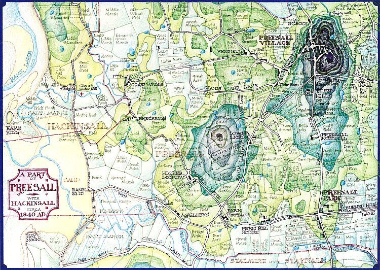
This part of the Township contains Preesall hill and other features of interest. The patterns, shapes and sizes of fields vary according to their location and age; the larger, more regular shapes tend to be more recently enclosed areas of marsh , moss and carr, whereas the smaller irregular shapes are found predominantly on higher ground and would seem to be of earlier origin. Many of the latter can be seen roughly in and around the triangle formed by the Village, Lickow and Preesall Park.
Ancient names such as Clod's Carr and Medlar still survive from the 12th. century or earlier and the site of Geoffrey's mill, recorded on the O.S. map, is also commemorated in the names Great Mill Field and Little Mill Field. Agglebys and Lickow also date back to the Middle ages, and Monk's Lane still marks the line of the right of way granted by Geoffrey to the monks of Cockersand, this section being the final link to the High Road.
Recent developments would be the Poor Hall at the bottom of Cartgate and the new Preesall Windmill, a masonry tower mill replacing the old wooden peg mill on top of the hill, burned down in 1839. An embankment of sorts has been constructed from the site of Geoffrey's mill to Hay Nook in Stalmine, but it is noted that high water spring tides penetrate up the Grange Pool valley almost as far as Agglebys, the lower stretches still being Knepps or salt marsh intersected by obviously artificial drainage ditches. The later stone sea wall linking the island of Hame Hill to the mainland has not yet been built.