
Map 8 Stalmine Village. c. 1840
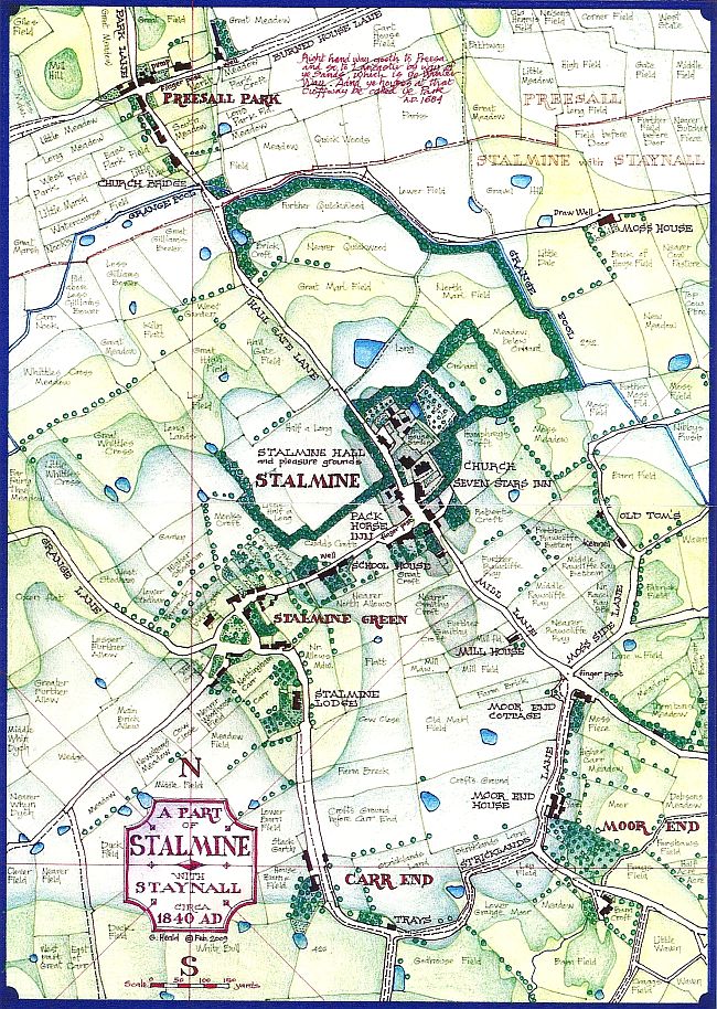
Stalmine village exhibits a looser form than Preesall, coalescing around two centres rather one. On the higher site is Stalmine Hall and its grounds, the Church, and two Inns, the Seven Stars and the Pack Horse, plus a few other buildings. Downhill, in a small depression called Stalmine Green, is a Village Green surrounded by cottages and farmhouses. The Schoolhouse is half way between the two. Strangely, no shops are enumerated. Other very minor settlements, Moor End and Carr End, lie a short distance to the south.
The Parish Church served the whole of Preesall and Hackinsall as well as Stalmine, and it has been noted that the Vicar lived in Preesall. This situation only changed with the construction of St. Oswald's church, initially as a chapel of ease, in Preesall at the end of the 19th. century. The money for the construction of St. Oswald's was raised by various forms of public subscription; Abraham Heald of Preesall House was the Treasurer and one of the guarantors.
The Grange Pool, which drains Stalmine Moss into the Wyre, clearly follows a man-made course, since it cuts through higher ground to the north east of the Hall, bordered by an extenuated plantation of trees. Beyond this to the east the low lying ground of the moss extends for miles, the predominant pattern of fields being rectangular Moss Dales, higher meaning unexcavated, lower meaning that the peat has been dug out.
Immediately to the north, across the Grange Pool, lies Preesall Park, an important crossroads for centuries. In the Townley Hall maps of 1684 it was described thus "Right hand way goeth to Preesa and so to Lancaster by way of ye sands, which is ye winter way. And ye houses at that crossing be called ye Park". The other way to Lancaster lay across the Moss, which would appear to have been impassable in winter.