
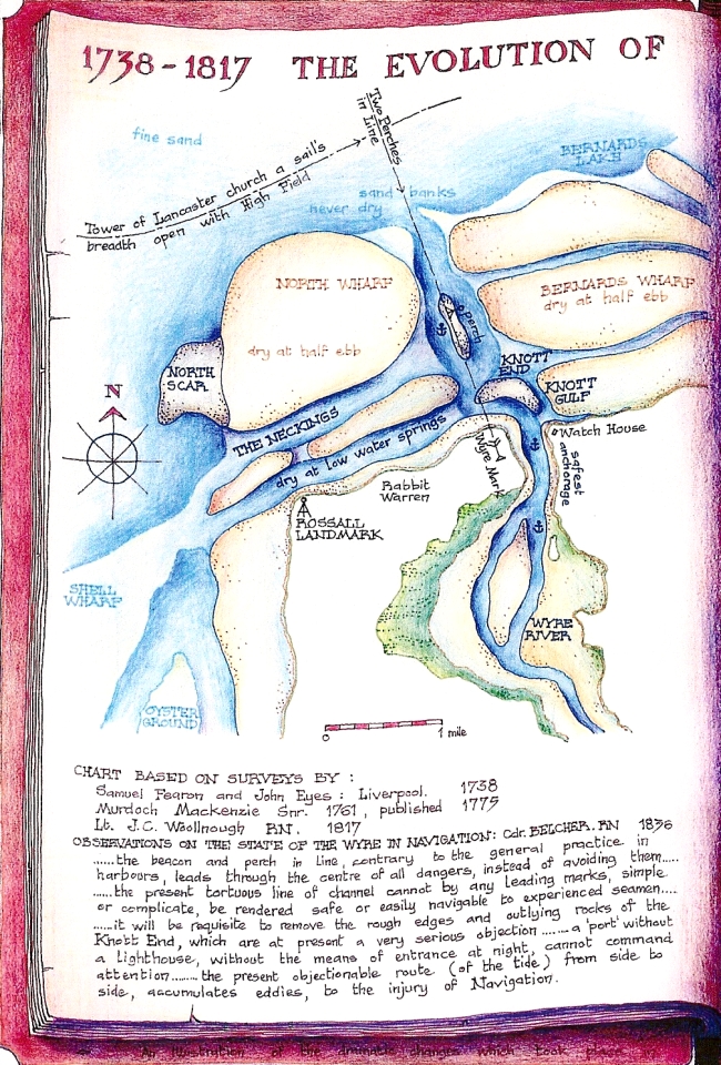
Map 10 Evolution of the Wyre Estuary. 18th. to 19th. Centuries AD
The first complete survey of the coast of Britain, Great Britain's Coasting Pilot, was commissioned by Samuel Pepys and carried out by Capt. Greenvile Collins in the early 1690s. Captain Collins work was of high quality but he did not survey the Irish Sea coast himself, relying instead on a compilation of local knowledge. However the Wyre is clearly shown running out at an angle considerably to the west of its present position.
The first fully detailed and accurate survey of the Wyre was published by Fearon and Eyes of Liverpool in 1738, a later one by Lt. J.C. Woollnough, RN. for the Admiralty following in 1817. Lt. Woollnough's 'fair sheet', drawn on board ship to show actual courses and soundings, is still extant.
These two surveys, almost 80 years apart, show little change during the intervening period. A meandering, partially obstructed channel runs out to the north and two considerable swatchways, the Neckings, run out to the west immediately offshore. A scar exists at the western end of the swatchways, where the ebb through them meets the northwards longshore drift of heavy material, some of which is swept out to form Shell wharf. There is only a curving, sandy shore at the north west corner of North Wharf.
During the 1820s and 1830s much work was carried out to improve access to the new Port of Fleetwood. The swatchways were closed off by piles, the tops of which can still be seen, at the eastern end; the northwards channel was straightened and dredged, including the removal of part of the great Knott; and the Knott Gulf Embankment was constructed to close off the newly forming channel around the east side of the Great Knott. All of this work was intended to direct the main flow of the tides through the north channel. Various lights and beacons were also erected.
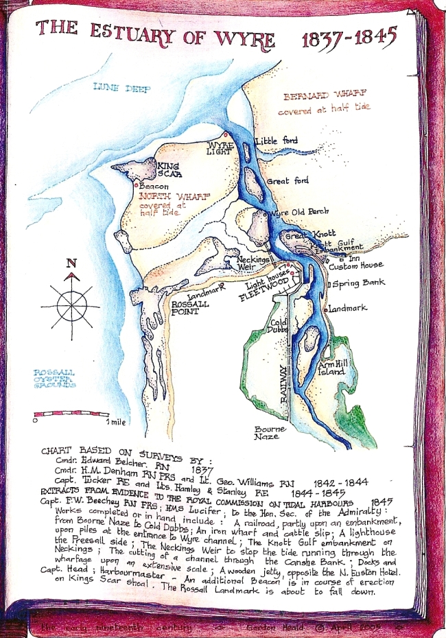
The next survey, carried out in 1837 by Cdr. E. Belcher RN., (a distinguished hydrographer, later to be the first British officer to raise the Union Jack over Hong Kong Island) showed that certain side effects had been produced. The scar at the west end of the Neckings had virtually disappeared but had reformed more than a mile further north, now named King Scar, at the point where the longshore drift now met the combined ebb of the Wyre and the Lune. Additionally a trench of great depth, known as Lune Deep, had formed. The next survey, by Cdr. H.M.Denham in 1842-44 confirmed the above.
Certain myths have since been attached to rhe strong, curving, steep-sided accretions of stones at King Scar, namely that they are man-made and date back to the Roman period - an obvious impossibility since they did not exist before the 1820s .
This point has been reinforced by the subsequent development of King Scar by entirely natural forces into a major feature with ever larger and higher stone embankments. There was minimal change during the hundred years following the works carried out to the harbour and channels in the 1820s and 1830s which produced the changes in tidal flows resulting in the initial accretion of material, still covered by every high tide until comparatively recently. However the natural process of accretion has resumed and accelerated in recent years and the Scar is now only covered by the highest spring tides. n October 2015 it remained clearly visible as an extensive stony island at the top of a 9 metre tide and is said to have actually reached a height of 9.7 metres above chart datum. Highest astronomical tide is only about 10.4 metres !