
Map 12 The Hackinsall Hall Estate circa 1840 AD
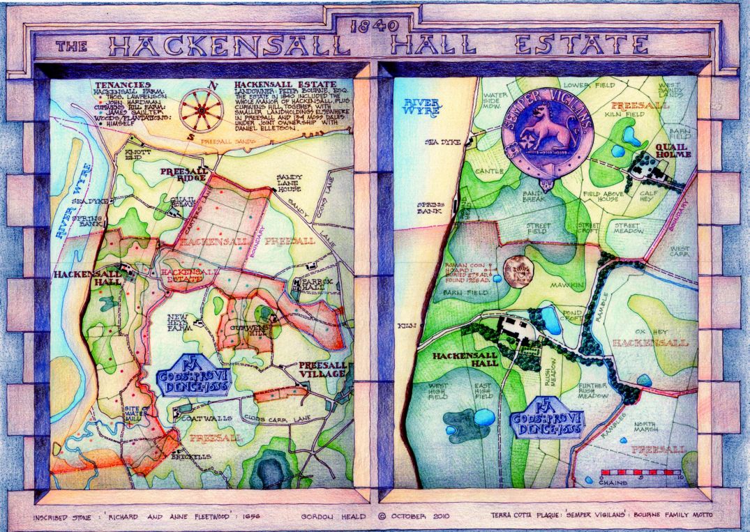
As noted elsewhere the site of Hackinsall has been occupied from the very earliest times, evidenced by the Roman coin hoard buried nearby soon after 273 AD. and found in 1926.The very name is derived from that of Haakon, a Norseman who must have made it his home, and its existence is further documented in a charter of 1189 AD. granting the Manor to Galfridus Arbalastarius.
A stone built into the wall records rebuilding work carried out in 1656 AD. by Richard and Anne Fleetwood, the last owners of Hackinsall to actually live there. It was their nephew, also called Richard, who in 1695 AD. founded a school in Preesall known as Fleetwood's Charity School which still flourishes today, albeit on a new site on top of the hill. The estate was sold in 1729 and eventually came into the possession of the Bourne family, whose motto 'Semper Vigilans' was inscribed on a terra cotta plaque built into the barn wall during a late 19th. century reconstruction.
The most striking feature of the Hackinsall Estate in 1840 AD. is that the landholding of the owner, Peter Bourne, encompasses the whole of Hackinsall, its boundary following precisely that between the townships of Hackinsall and Preesall,only with the addition of Curwen's Hill. This may indicate, as in the case of the Parrox Demesne, that the extent of the landholding dates back to the original division of the Manor into four quarters in the late middle ages. It is curious that a projecting tongue of Hackinsall , consisting of low lying, marshy ground, extends right up to the foot of Preesall hill, dividing the Parrox estate into two parts.
The field layout may also have been unchanged for centuries, displaying as it does the ancient ridge and furrow configuration demarcating the medieval strip system of agriculture. This can be seen most clearly in the area now occupied by the golf course, which has entirely escaped 20th. century deep ploughing. Interesting field names abound, most notably three adjacent fields along the Hackinsall boundary with the word 'street' in their names, which would generally indicate the presence of an ancient road, in this case leading directly to the important site of Spring Bank and connecting back in a straight line of paths and tracks to Parrox and beyond
The Tithe survey of 1839 also records that the estate was occupied by two tenant farmers; Thomas Lawrenson, who farmed most of the higher ground in the southern and western parts; and John Hardman, who farmed the low lying northern part plus the salt marsh adjacent to Hame (Arm) Hill. The two tenants occupied separate parts of the Hall and must have divided the farm buildings between them. A third tenant, James Gaulter, farmed Curwen's Hill and the low lying eastern tongue of Hackinsall. ''