
Preston Pinfolds
A pinfold (OE. pundfald) is an enclosure for cattle or other animals that have been found roaming the streets or trespassing on land for which the owner of the animals does not have permission. The animals would then be restrained in the pinfold until the owner redeemed them - normally by paying a small fine. Pinfolds were found in towns and villages from, at least, the middle ages onwards.
In Preston, the pinders (in some areas called an "hayward"), normally two of them, were appointed by the town council to be responsible for safety & welfare of the animals. The pinders (or pound-keepers) were obliged to receive everything that was offered to his custody but the feeding of the animals was the responsibility of the restrainers until the animals were redeemed. In addition, they were also responsible for making sure that the pasture rights to the various moors controlled by the Council were not violated by non inn-burgesses. Even inn-burgesses (freemen) were restricted by the number of animals they could graze on the commons and even the times when the commons could be used. The various presentments in the Court Leet records (1653-1813) provide a glimpse of the pinders role as well as the uses the pound was put to. Interestingly, more often than not, any presentment that gives a ruling on the role also gives fine against the pinders if the ruling wasn't followed - an early case of payment by results.
The first, surviving, record (October 1653) contains the following comment:-
Wee pr'sent John Singleton for breaking the pinfold, and doe therefore amerce [fine] him in iijs. iiijd.
According to Anthony Hewitson, in his partial transcription of the leet records, the pinfold was on the North-East corner of Preston Marsh opposite the present Wheatsheaf pub - but this would appear to be a much later construction. Hewitson also mentions that the landlord of the pub was the last pinder in Preston.
In addition to their duties with respect to animal trespass, the pinders were often called upon to police the common rights of freemen/burgesses of the town. A presentment in February 1654 commented upon the requirement for cattle not to be released onto the marsh before 6 am. Any earlier and the pinders should impound them or forfeit 12d. A similar presentment at the same court mentions geese that should be kept away from the marsh between the 25th March and the 29th September - presumably to protect the grazing since a presentment in April 1656 has the comment that the geese were
destroyinge of ye Arbish [herbage] of ye marsh
Any offender could be fined 20s for such an offence or, if they tried to rescue any of the animals, the fine was 3s 4d for every goose.
A common complaint in the records was that of damage produced by
swyne in mens corne and grass
But this went further in that swine seemed to be free to roam the streets - especially on market days. By the time of the October 1660 court the situation had got so bad that notice was given that all swine should be ringed within 5 days after notice. The default fine being 6d with half going to the town and half to the pinder.
The pinders seem to have a difficult task in deciding ownership of various beasts put on the moor. Freemen had rights to the common but stallengers, who paid to have access to the market, were denied this right and, in 1656, were fined 3s 4d for each animal found. Animals that had ailments would be refused access to the marsh by the pinders in order to avoid transmission of any disease.
Although not specifically associated with animals the pinders were given other requirements. February 1669 states that the pinders should
rake and gather the sticks and wrecke from of ye marsh and burne ye same, and spread ye Ashes, before ye xxth of Aprill next
The marsh would have been common land and keeping it in good order for grazing would have been a perk of being a freeman. Another presentment mentions opening a watercourse and this aslo would be monitored by the pinders - presumably this was because the watercourse impinged on the marsh. The pinders in 1698 seem to have expanded their role in reporting rails being missing from cellers, rampires (barrier against flooding) not repaired and middings being found in the middle of St. John's Weend.
Almost every sitting of the court would have some form of reference to the fold being in need of repair or someone breaking (rescuing) their animals from the pound without payment. The court for October 1654 implies that an earlier pinfold was poorly constructed - probably with wood.
That the Pinfold called the sheep ffould is gone to decay and ruinated, and that the now Bailiffes do repaire the same with Breecks before 25th of March next upon paine of xxjs iijd.
Three successive presentations in October 1658 give an idea of the disputes that occur:-
Jon. Singleton for takinge his horse from Jon. Comberall, beinge goeinge wth the said John Singletons horse to ye pinfold at 12 sevrall tymes therefore to pay for either offence ijs. vjd. a peece.
Ye said Jon. Singleton for makinge a tustle and strikinge the said John Comberall when hee rescued his horse, and therefore to pay ijs. vjd.
and ye said Jon Singleton for swearinge one oath iijs. iiijd.
This level of violence wasn’t an infrequent occurrence. A number of the presentments mention “tustles” with the pinder when the owner tried to release animals without paying the fine. If blood was spilt in these tustles it was often known as a “bloodwipe” and the fine doubled.
The court, meeting in February 1665, provides some idea of the internal structure of the fold.
The now balives shall cause a pticon (partition) wall erected to make a sepacon (seperation) wthin the pinfould to keepe sheepe from other Cattle from harme and desruccon and likewise for to rpair there in needfull places according to the 12th prsentmt of the last Jury of Leete at or before the 24th of June next upon paine of xxs.
In April 1724 “force & violence” occurred and it also tells us that the pound was locked to prevent release of the animals without paying a fine.
Jno Whalley for abusing and assaulting one of the Pinders of this Town and forcibly takeing ye key of the pinfold from his wife by force & violence taking his goods out of the ffold impounded for the trespass & thereby comitting a pound breach & do Amerce him in xiijs. iiijd.
The presentation for April 1761 gives a further indication of the structure of the pinfold
The Bailiffes for not repairing the Pinfold there wants an Inner Door, repairs at the Outward Door, some Brick work, some paving, and the Rubbish & Dirt cleaning out Which We order to be done within thirty days after Notice or the said Bailiffes to pay 30s.
Most pinfolds that are still extant wouldn’t have had the space for any form of internal structure so this, original, pinfold appears to be the deluxe model.
The court of October 1771 contained three successive presentations describing where the pinfold door together with the staple lock had been broken and the impounded animals released.
The court records from this point now become sparse until the time the records run out (1813.) With the rapid increase in population of the town the Court Leet became an anachronism. Fortunately information starts to appear in the newspaper records.
The Preston Guardian for June 26th, 1847 contains a report on court case in Preston where William Bond was charged by Joseph Brown with rescuing a number of sheep & cattle from the pinfold. He was found guilty and was required to cover the costs and the expense of replacing the door.
The same newspaper for August, 1856 described how a horse was found by a policeman straying upon the highway and it was impounded. The owner was a James Harrison (a carter) and was impounded for more than a month. The pinder, John Threlfall, had expended £1 2s maintaining the horse and this was recovered with costs.
A 1858 case gives some background to the processes involved when impounding animals. John Thompson had some land near Old Lancaster Lane and John Daly, his wife and James Hodgkinson persisted in pasturing his goats on Thompson’s land. Eventually Thompson had had enough and took the goats to the pinfold. The newspaper article on this case then describes how Thompson took the “tickets” off the pinder and gave them to Mrs Daly. These tickets, presumably, informs the owner that their animals are in the pinfold. A scuffle took place between the different parties which then ended up in a court case.
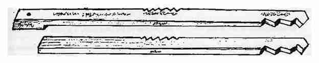
It isn’t obvious if these “tickets” were written out in a modern fashion - especially in a time of low literacy. It was more likely to involve some form of tally where a stick had some notches cut in it and then the stick split into two; one for the inpounder of the cattle and the other for the pinder. Only when the impounder had been paid for any damage would his half of the stick be given back to the owner, the two matched and the animals released.
A case from 1859 involves Daniel Greenhalgh (a butcher in Ribbleton lane) and George Rawcliffe who had wrongly impounded two of the plaintiff’s cows in the Marsh End pinfold and kept them there two days and nights without “meat” (presumably meaning food). It had cost Greenhalgh 8s 6d to get them out and they had been giving 6 or 8 quarts a day of milk less after being impounded. Under cross-examination the plaintiff explained that the two had fields adjacent to each other and the defendant had insufficient fences to keep cattle out of his field. A witness, James Smith, verified this but suggested to the two parties that they settle the matter but they wouldn’t. After putting the cows in the pinfold, Rawcliffe called at Greenhalgh’s house and told his wife - the plaintiff ran after him saying he “he would punch him”. The “Pounder” (John Threlfall) was called to give evidence. Greenhalgh came to him the night the cows were put in and wanted to take the cows out and put them in his field. This was not allowed - presumably because the pounding fee hadn’t been paid to Rawcliffe. Threlfall then volunteered to take care of the cows & milk them. This wasn’t allowed. Later Greenhalgh got the key to the fold from the pounder’s son and got the cows out. According to the law cows could be kept in the pound for 24 hours without meat but, normally, this would be 12 hours. Eventually Ellen Rawcliffe, the defendant’s wife gave evidence. Explained that James Smith came to settle the matter and he paid 5s for the “tallies” which was understood to be a settlement of the matter.
Where were the pound(s)?
The earliest indication of the possible location of the pound can be garnered from the following Leet presentation (February 1678)
Mr Thomas Martin, Roger Haydocke, Henry Gradwell, Edward Porter, Henry Bretherton, Willm Holder, Ralph Woodhouse, Robt Spencer and Laur Bullen that they remove their middings at Spittle Mosse and nere pinfold before ye xth of May next upon paine of iijs. iiijd. apiece.
Spittle Mosse was the area to the west of the present Fylde road which, as we will see later, would tie in with the 1774 Lang map.
A number of the Leet presentations pinpoint the pinfold to just outside the barrs on Fishergate. These “barrs” mark the north-western entry into the town and were used to control access to the town - especially on market days. The barrs would have been on Fishergate just above where Back lane (now Great Shaw street) comes in. No detailed maps for this time have survived but the Kuerden/Strip maps from around 1684 give a glimpse of geography of the town.
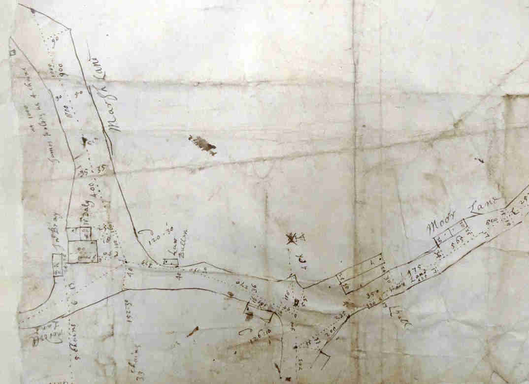
On this map Friargate comes in from bottom-centre with Moor lane veering off to the right. The lane to the left is named Marsh lane which is now known as Fylde road. Peter Smith (prestonhistory.com) has produced a more understandable version of this map.

A series of presentations in the 1680’s can be used in narrowing down the date of the “Kuerden/Strip” maps. February 1683 has the following:-
These psons following (...Widow Bray...) yt they remove thir middings betwixt Spittle mosse and ye ffryergate barrs before ye 10th of May upon paine of 6s. 8d a peece.
The burial records for St John’s show John Bray being buried on the 30th January 1683 (Julian calendar) or 1684 (Gregorian calendar) so the maps had to have been surveyed before this date.
The first map that gives a more definitive indication of the position of the pinfold appears in J. B. Lang’s map from 1774. Friargate appears from the bottom right; Maudland the diagonal road and Fylde road to the left of the Windmill field.

This pinfold (or, at least, the pinfold field) appears to be adjacent to Fylde Road/St Peters and would continue in this position until the coming of the canal in the 1790’s when John Horrocks bought a large portion of Spittle moss for his cotton mill (Moss mill). An 1796 indenture, where Horrocks acquired “Brays Garden” from Richard Atherton, a map of the land was attached. This shows the pinfold at the top of Brays garden - just over the road to Maudland. Records for Everton 1787 mention a pinfold and cage. Presumably the "cage" was the smaller enclosure and the pinfold, the field.

One of the provisos, in the acquisition of the land from the council, was that another pinfold be created nearby. According to the Corporation records (CNP 3/1/4), John Horrocks started buying up land on Spittle Moss by the 23rd October, 1795. The same document records for 7th August, 1797 that
The present pinfold be pulled down and a new one erected upon such a part of the Spittle Moss as Mr Green shall approve and of such dimensions as he shall prescribe. Such a pinfold be pulled down at the sole expense of Mr Horrocks… be allowed the old material for this purpose…..the site of the present Old pinfold shall be given up and be appropriated towards enlarging the road leading through the Maudlands as well as that leading towards Spittles moss
This discussion regarding the movement of the pinfold continued for several years and it may be that it was temporarily moved further north onto Spittle moss. Another document, dated 1798, describes the rental of a plot of land to Horrocks by the Corporation of Preston being to the east end of the new pinfold.

The Corporation records for 1805 show that land was set aside for the new pinfold close to the "Dog kennels". Shakeshaft's map of 1808 does show "Dog kennels" adjacent to Moor Brook and a map of 1835, which was produced to show the enclosure of Moor Park, highlights a pinfold at the corner of St George’s Road and Garstang Road - so it looks like the pinfold moved between those dates. Corporation records (CBP 1/1 for 1836) give a bill for £44 10s 4d for the construction of the "new" pinfold.

Although not shown on this map, this area around the pinfold would later be used as a cattle market. This would make sense since any cattle not redeemed could be taken to market to pay for their upkeep. A relic of this feature can be seen in the original name of the Unicorn public house - the Cattle Market. The strange thing about this map is that it shows St George’s Road and yet the 6 inch, OS map published in 1849 and surveyed between 1844 and 1847 fails to show it. It is likely that this pinfold was only a temporary solution since the tithe map and the early OS maps fail to show it. As we will see later, a number of newspaper articles in the 1840’s and 1850’s refer to using the “marsh” pinfold even the animals were found straying in the Ribbleton area. This implies that this pinfold had closed down.
Ashton, at different times, possessed at least two pinfolds.

The pinfold on this map, almost opposite the end of Water Lane, is probably the one referred to by Hewitson as it is opposite the Wheatsheaf pub and in the area now occupied by the Grand Junction pub. This implies that the land was redeveloped by the mid 1860’s. The pinfold only appears on this tithe map for 1840 and is missing from the, slightly later, OS maps. The Preston to Blackpool railway must have been under construction at the time of the map survey.
The 6 inch OS map for 1849 shows a pinfold (and pinfold house) on Pedders lane. Strangely this does not appear on the 1840 tithe map for that date. Possibly it was the Water Lane pinfold that had been moved further out of Ashton - onto Pedders lane.

On the other side of Preston, in Fishwick, another pinfold can be found. Fishwick was incorporated into Preston borough after the 1832 Reform Act but the pinfold could easily have existed prior to this date.

The 1849 OS maps positions it south of New Hall Lane and, by 1893, the pinfold is called “Old Pound” and the area around it known as “pinfold”. By the 1930’s all of this area had been redeveloped but still a “pinfold street” still exists, slightly to the north of the original pinfold.
Fulwood had its own pinfold in the 1840’s. It is shown on the 6 inch OS map just off Fulwood Row. On the tithe map schedule the land was owned by Fulwood Township Surveyors.

Although the Corporation Arms in Lune street never appears in any official maps or records it seems that it must have been used as a pound. A court case reported in the Preston Chronicle for the 25th April, 1835 where a pig was the cause of a dispute over ownership. The animal had strayed and was impounded at the Corporation Arms until the rightful owner claimed it. Another article, appearing in the Lancashire Evening Post in July 2001, has the recollections of someone who was born in the Corporation Arms in 1921. The article continued "because of the extensive stabling facilities, it was the Corporation pound and any stray livestock found in the town was brought in until claimed. This area was only developed after the canal wharves and Corn exchange (eventually the Public Hall) were built. The first record of the Corporation Arms appears around this time (1812) and probably doubled up as a pound due to the nearby market.
More pinfolds can be found further out on the edge of Preston. One appears on the first 10000 OS very close to the Saddle Pub at the corner of Sidgreaves lane and Lea lane. Several records also refer to this pound eg DDHo/207 which passes the pound when circumnavigating the boundaries of the De Hoghton estate (dated 1814). By the 1890’s Ordnance Survey series, the pinfold had disappeared.
Analysing the tithe maps for Ashton, Lea & Cottam reveals a pinfold near, what is now, Valentines House in Cottam. There is no sign of this on the ground and most of the land is now part of UCLan Sports arena.